
Joint US–Indian Spacecraft Maps Rapid Land Sinkage in Mexico City
Mexico City is sinking fast. New NISAR satellite data reveals extreme land subsidence, exposing risks to infrastructure and highlighting urgent monitoring needs.


Mexico City’s Rapid Subsidence Captured by New NISAR Radar Data
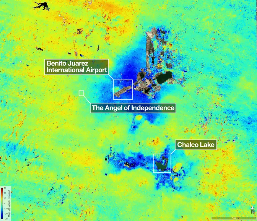
New measurements from the NISAR mission reveal that parts of Mexico City and surrounding areas sank by several centimeters per month between late October 2025 and mid-January 2026. Although these shifts may appear minor, decades of uneven ground movement have fractured roads, damaged buildings, and strained water infrastructure across the region.
A Powerful Radar System Tracking Earth’s Subtle Movements
NISAR — a joint NASA and ISRO satellite launched in July 2025 — is one of the most advanced radar systems ever placed in orbit. Its L-band synthetic aperture radar can detect ground motion through clouds, vegetation, and darkness, enabling consistent monitoring of Earth’s surface. The mission is designed to track changes such as land subsidence, glacier flow, and agricultural activity with high precision.
Why Mexico City Is Sinking
Home to roughly 20 million residents, Mexico City sits atop an aquifer that has been heavily pumped for more than a century. Combined with the weight of urban development, this extraction compresses the ancient lakebed beneath the city. Engineers first documented the sinking in 1925, and by the late 20th century some districts were dropping more than 35 centimeters per year, affecting major infrastructure including the city’s Metro system.
What the New NISAR Data Shows
Preliminary NISAR observations from the 2025–2026 dry season highlight areas subsiding by over 2 centimeters per month, shown in dark blue in the mission’s analysis. Yellow and red zones represent noise that will diminish as more data is collected. Landmarks such as Benito Juarez International Airport and Lake Nabor Carrillo stand out clearly in the radar imagery.
A City Monument Marking a Century of Sinking
The Angel of Independence, built in 1910, has become a visible marker of the city’s gradual descent. As the surrounding ground has lowered, 14 additional steps have been added to the monument’s base to maintain access.
Global Implications for Monitoring Land Change
Scientists expect NISAR to transform how rapidly changing landscapes are monitored worldwide. Its long-wavelength radar is particularly valuable for regions where vegetation or coastal conditions make traditional surveying difficult. Researchers anticipate a surge of new discoveries as the satellite continues its global coverage.
A Joint NASA–ISRO Mission
NISAR is the first satellite to carry two synthetic aperture radar systems operating at different wavelengths. NASA provided the L-band radar and large antenna reflector, while ISRO contributed the spacecraft bus and S-band radar. The mission observes Earth’s land and ice surfaces twice every 12 days using its 12-meter-wide reflector — the largest radar antenna NASA has ever deployed in space.
Learn More About the Mission
For additional details about NISAR and its ongoing scientific work, visit the mission’s official website.
Reward this post with your reaction or TipDrop:
 Like
0
Like
0
 Dislike
0
Dislike
0
 Love
0
Love
0
 Funny
0
Funny
0
 Angry
0
Angry
0
 Sad
0
Sad
0
 TipDrop
0
TipDrop
0